
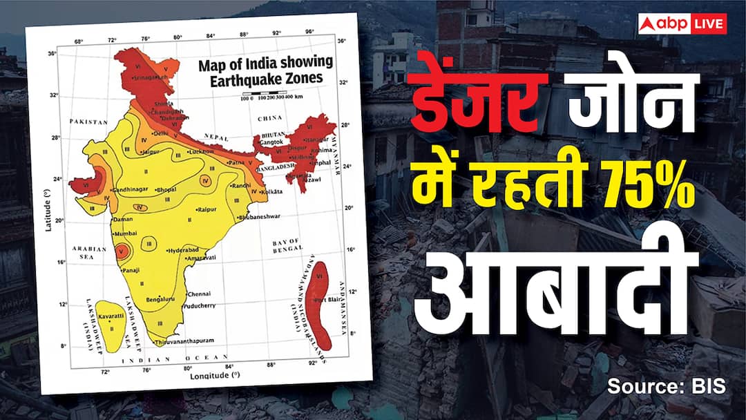
The Earth is made up of 4 layers, which include the inner core, outer core, mantle and the topmost layer is the crust. It is in this crust that there are tectonic plates, which cause earthquakes when they collide with each other or shift from their place. When the Earth was formed 4.6 billion years ago, high mountains were formed due to the collision of these plates, the Himalayan range is also one of these. But now India has released a new earthquake map, in which the plates of the Himalayan range have not moved for 200 years. That means a huge earthquake can occur at any time. At the same time, 75% of the country’s population is living in the new Danger Zone VI. In ABP Explainer, let us understand what is the new earthquake map of India, what major changes were made and what is going to happen next…
Question 1- What is the new earthquake risk map of India?
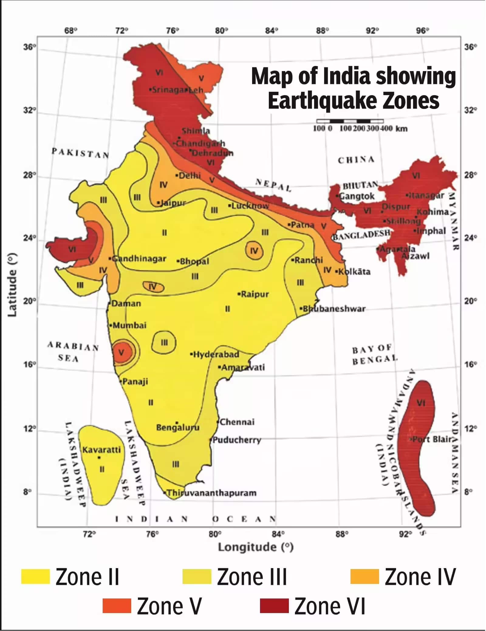
answer- Bureau of Indian Standards (BIS), an organization of the Government of India, has released a new earthquake risk map. this map ‘IS 1893 (Part 1): 2025’ It is part of the name code and has been implemented in the entire country from January 2025. Its full name is ‘Seismic Zonation Map’, which divides the country according to the risk of earthquake. The old map was of 2002, which was slightly updated in 2016, but now this new map has been made more accurate. Its purpose is to protect new buildings, bridges, highways and big projects from earthquakes, so that construction projects do not collapse in earthquakes and loss of life and property is reduced. BIS has said that from now on all engineers will have to use this new map.
Question 2- How different is the new map compared to the old map?
answer- Earlier India was divided into four main zones…
- Zone II-Low Danger
- Zone III- Moderate Danger
- Zone IV- high risk
- Zone V- Highest danger
Earlier there was also Zone I, but it was merged into Zone II. Now the new map also keeps the same four zones, but Zone V, with the highest danger, has been more strictly defined. It has been described as ultra-high risk or Zone VI because its danger is considered to be greater than before. Overall, 61% of the country’s area has now fallen into moderate to high danger zones III to VI, whereas earlier it was 59%. At the same time, 75% of the country’s population lives in the most dangerous areas. This change in the new map has been done using the Probabilistic Seismic Hazard Assessment (PSHA) method, which is better than the old historical data.
Question 3- What is the biggest change regarding the Himalayas in the new map?
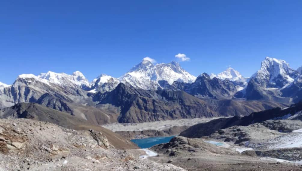
answer- The biggest change has taken place in the entire Himalayan region, which is called the Himalayan Arc. Earlier, some part of the Himalayas was in Zone IV and some in Zone V, but now the entire hilly area from Kashmir to Arunachal Pradesh has been put in the same highest danger Zone VI. Vineet Gehlot, director of the Wadia Institute of Himalayan Geology, said the old map did not properly understand the locked segments of the Himalayas, where stress has been accumulating for 200 years. Now this map has been made considering the fault lines, magnitude and soil type, hence the plain areas around the Himalayas like Dehradun, Haridwar will also be more cautious.
Question 4- Why was this done in the Himalayas, even though earthquakes had occurred there before?
answer- Yes, earthquakes used to occur, but new research has revealed that the Indian Plate and the Eurasian Plate are colliding beneath the Himalayas and at many places the plates have been locked for 200 years. Lock means it can’t move, so there’s a lot of force accumulating there. When this lock opens, an earthquake of magnitude 8 or more may occur. Reports from the National Center for Seismology (NCS) and the National Disaster Management Authority (NDMA) say that the next major earthquake could occur anywhere in the Himalayas. For this reason, BIS has put the entire Himalayas in a single Zone VI so that buildings get the strongest design, which can withstand high peak ground acceleration (PGA).
Question 5- Is South India out of danger in the new map?
answer- There is very little change in South India because the land there (Peninsular India) is very old and stable. The tectonic plates there are not very active. Most parts of Tamil Nadu, Karnataka, Andhra Pradesh and Kerala are still in Zone II or III, i.e. low or moderate risk. With the new map, the buildings there will be made a little stronger, but not as tough as Zone VI in the Himalayas. However, the risk of liquefaction (soil melting) has been seen in some coastal areas.
Question 6- How reliable is the new map?
answer- This is the most reliable map so far. BIS created it after 10 years of research, which included Wadia Institute, NCS and international experts. The old map was based only on old earthquakes (like 2001 Bhuj, 2015 Nepal), but the new one is made using the PSHA method. It includes GPS data, satellite imagery, active faults and millions of simulations. This method is used in countries like Japan and New Zealand. As a result, now the danger estimate is based on 2.5% probability in 50 years, which is more accurate.
Question 7- So will we now be completely safe from earthquakes?
answer- According to experts, no one can be completely safe, but the loss will be reduced by 80-90%. Earlier, weak buildings constructed in Zone IV-V used to collapse, but with the new rules the buildings will neither move nor collapse. Now 61% of the area will have strict design and 75% of the population will benefit. The NDMA report says that if we update even the old buildings, deaths in future earthquakes will be much less.
Question 8- When did the biggest and most dangerous earthquake occur in India?
answer- The 3 biggest earthquakes have occurred in India so far…
- Andaman’s Indira Point sank due to earthquake and tsunami in 2004: Indira Point of Andaman and Nicobar Islands sank due to the earthquake and tsunami that struck Indonesia on 26 December 2004. This earthquake caused devastation in 14 countries including India, Sri Lanka and Indonesia. The tsunami generated by this earthquake reduced the height of Indira Point by about 4.24 meters. About 1.7 lakh people died in this disaster.

- Devastation caused by earthquake in Kutch, Gujarat in 2001: In 2001, an earthquake of 6.9 magnitude occurred in Gujarat, which affected 24 districts of Gujarat. It caused maximum devastation in Kutch, Surendranagar and Radhanpur. 7,904 villages were destroyed in this earthquake. About 17 thousand people died and 1.67 lakh people were injured. In Bhuj of Kutch district, more than three thousand people died and 90% of the houses were damaged.
- Island formed in Bhuj due to earthquake 204 years ago: In 1819, an island was formed due to an earthquake in Bhuj, Gujarat. It is known as Allah Bandh. Its intensity could not be known, but it is believed that this type of island was formed due to an earthquake of more than 7.8 intensity.